There are 15,508 residential buildings in flood zones, representing more than 19,000 households and at least one long-term care facility.

Article content
The number of residential buildings considered to be in flood-prone zones in the Greater Montreal region will double to about 15,500 according to preliminary flood maps unveiled by the Montreal Metropolitan Community (MMC) council on Monday morning.
Residents whose homes are near waterways have been anxiously awaiting access to these maps, which are now publicly available on the MMC’s website. The maps were drawn up this summer according to guidelines set out in the province’s proposed flood-management regulations, unveiled last June. They are considered preliminary until those regulations are adopted by the National Assembly in the spring, but the CMM has decided to make them public during the period of public consultation.
Advertisement 2
Story continues below
Article content
In a statement released Monday, the MMC council called the Quebec government’s proposed flood management regulations “a good start,” but said that if they are not amended they will prevent adaptation for flood resilience in a large portion of Greater Montreal, especially in areas situated behind current or future flood prevention structures, such as dikes.
In a technical briefing to reporters last week, Nicolas Milot, the MMC’s director of Ecological Transition and Innovation, presented the position of the MMC and explained why these maps are of great concern to those living in or near flood zones.
“Some people who were not in flood zones before are in flood zones now,” he said. “Some people who were already in flood zones are now in more severe zones with this flood mapping. So (building) restrictions will rise for each particular situation and in some cases we have to consider that the fact of being identified in a really high-risk zone means … that banks, insurers, will probably re-evaluate the pertinence of continuing to insure or issue mortgages for these houses. We don’t know yet how they will react.”
Advertisement 3
Story continues below
Article content
Flood maps of certain parts of the region had not been updated since the 1970s, and risk levels have increased significantly in recent decades. The new regulations will see increased rules for municipalities as to whether they can authorize development in flood zones and will tighten rules around the maintenance of flood protection structures, such as dikes.
Along with the maps, the MMC council adopted a brief that includes the regional body’s demands for changes to the proposed flood-management regulations. The regulations spell out what kind of development cities can allow and what kind of renovations homeowners can make to their properties in flood zones, which are going to be divided into four levels of severity: low, moderate, high and very high.
Homeowners can input their addresses to find out what zone their homes are in, but Milot stressed the maps are preliminary. He said they may change slightly before the regulations are formally adopted next spring.
He said the CMM has no argument with science of defining flood zones.
“It’s science. It’s fact. We have engineers who have done their best, with all the science behind them, to present in good faith the probabilities of being flooded. That’s what’s on the map. The choices we can make, and that will affect the citizens, is what kind of rules do we apply in those zones.”
Today’s One Read
Article content
Advertisement 4
Story continues below
Article content
The new maps take into account flooding events in recent years, notably 2017, 2019 and 2023, uncertainty linked to climate change and the possibility that such water management systems as dams and reservoirs can fail. The result is an enlargement of flood zones in Greater Montreal.

In the past, Quebec had only had two categories of flood zones: “O to 20-year,” which meant flooding is expected to occur at least once every 20 years, or 20-100 years, which meant flooding could be expected to occur between once every 20 years and once every 100 years.
The draft regulation describes four levels of flood risk. The colour-coded risk levels describe both the probability of flooding and the expected level of severity (depth of water).
Dark red or “very high” risk
A greater than five-per-cent chance of being flooded in a given year, to a depth of more than 30 centimetres.
Lighter red or “high” risk
A greater than five-per-cent chance of being flooded to a depth of up to 30 cm, or greater than one-per-cent chance of being flooded to a depth of more than 30 cm, or more than a 0.3-per-cent chance of being flooded to a depth of over 60 cm.
Advertisement 5
Story continues below
Article content
Orange or “moderate” risk
A greater than a one-per-cent chance of being flooded to a depth of up to 30 cm, or greater than a 0.3-per-cent chance of being flooded to a depth of between 30 and 60 cm.
Yellow or “low” risk
A greater than 0.3-per-cent chance of being flooded to a depth of up to 30 cm.
-

Marc Traversy gathers demolition debris from his Dorval basement while cleaning up after flooding caused by the remnants of tropical storm Debby Aug. 20, 2024.Photo by John Mahoney /Montreal Gazette
-

Suzanne O’Hara’s Dorval living room is packed full of possessions from her basement after flooding caused by the remnants of tropical storm Debby, Aug. 20, 2024.Photo by John Mahoney /Montreal Gazette
-

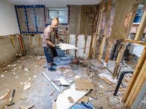
Marc Traversy gathers demolition debris from his Dorval basement while cleaning up after flooding caused by the remnants of tropical storm Debby Aug. 20, 2024.Photo by John Mahoney /Montreal Gazette
-

Marc Traversy rented a car shelter to protect belongings from his flooded basement Aug. 20, 2024, nearly two weeks after the remnants of tropical storm Debby flooded homes in Montreal.Photo by John Mahoney /Montreal Gazette
-

Marc Traversy gathers demolition debris from his Dorval basement while cleaning up after flooding caused by the remnants of tropical storm Debby Aug. 20, 2024.Photo by John Mahoney /Montreal Gazette
-

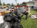
A mound of garbage remains outside an apartment building on Thimens Blvd. in the St-Laurent borough of Montreal Aug. 20, 2024. The residents’ possessions in storage lockers were ruined as a result of a storm Aug. 9 that flooded the building’s garage and basement.Photo by John Mahoney /Montreal Gazette
-

Suzanne O’Hara walks among her possessions, which are protected by tarps Aug. 20, 2024. Her Dorval basement flooded Aug. 9 during rainstorms from the remnants of tropical storm Debby.Photo by John Mahoney /Montreal Gazette
-

A mound of garbage remains outside an apartment building on Thimens Blvd. in the St-Laurent borough of Montreal Aug. 20, 2024. The residents’ possessions in storage lockers were ruined as a result of a storm Aug. 9 that flooded the building’s garage and basement.Photo by John Mahoney /Montreal Gazette


All 8 Photos for Gallery
Function Not Available
Full Screen is not supported on this browser version.
You may use a different browser or device to view this in full screen.
Advertisement 6
Story continues below
Article content
According to these categories, in the Greater Montreal region there are 15,508 residential buildings in flood zones, including: 3,204 in very high risk zones; 5,096 in high risk zones; 3,807 in moderate risk zones and 3,401 in low risk zones.
This represents 19,780 households, since some of the buildings are condo towers and there is at least one long-term care facility, Milot said. These buildings represent about $9.9 billion in property values, according to the municipal land evaluation roles, he added.
He said it’s important the province recognize that the region is facing a severe housing crisis and can’t simply relocate homes or stop all development in these zones.
“We don’t want to build in agricultural or natural areas, so to think we can just move these houses out of flood zones and put them elsewhere … there are major constraints.”
While the new regulations do not force the relocation of homeowners in any of the categories, each risk level is associated with different levels of constraints on building and renovating.
For example, homeowners in a very high risk areas face severe limitations on renovations and additions to their properties, because improvements raise property values, which means more costs to public compensation programs when floods cause damage. Property owners in very high, high and moderate risk zones are not permitted to demolish and rebuild their homes. In low risk zones, homeowners can demolish and rebuild, while following rules to improve flood resilience.
Advertisement 7
Story continues below
Article content
The MMC is demanding that homeowners in all but the very high risk category be allowed to demolish and rebuild as long as the new buildings would be resilient to flood damage. The MMC wants municipalities to be able to present development plans for flood zones that would allow for a softening of building restrictions, based on a careful risk analysis.
The MMC also wants regions that are protected by flood protection structures — such as dikes, pumping systems or derivation canals — be identified with a distinct colour designation (pink) to show they are protected. Another colour designation (purple) could be used to designate the “zone of precaution” (purple) immediately behind a structure that would be at high risk if the structure fails.
This would reflect the reality that while these areas are in flood zones, they are protected. New, stricter rules for maintenance of these structures by municipalities are part of the new flood management regulations and should make catastrophes like the rupture of the dike that caused flooding in Ste-Marthe-sur-le-Lac in 2019 exceedingly rare.
Advertisement 8
Story continues below
Article content
There are 4,651 residential buildings located behind flood protection structures in the Montreal region, including 1,072 at very high risk; 2,334 at high risk; 943 at moderate risk and 302 at low risk. If the province were to adopt the MMC’s recommendation about recognizing the impact of flood protection structures, 4,185 buildings would face less severe building restrictions than if these structures are ignored.
The MMC is also recommending improvements to the government’s compensation and relocalization programs for those in very high or high flood risk zones.
It is not challenging the province on its methodology for designating where the flood zones are, as this is a scientific process that has been done according to recognized criteria.
“The problem is that with the maps come the norms and rules that will affect how a citizen can modify his house, whether he can demolish to rebuild it,” Milet said. He said the concern is that with such strict rules in flood zones, these areas will eventually be abandoned, which may not make sense considering the public investments already made in these areas.
Advertisement 9
Story continues below
Article content
These zones are “already urbanized, roads are there, aquaducts are already there, sewage systems are already there. Do we really need and want to leave these infrastructures to go somewhere else or can we adapt these places (to reduce the risk) and to continue to live there but with more resilience and with (homes) that are less vulnerable to flooding?”
Public consultations by the Quebec environment department on the proposed flood management regulations ended on Sept. 17, but written submissions will be accepted until Oct. 17.
Recommended from Editorial


Advertisement 10
Story continues below
Article content
Article content
Comments